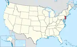
နယူးဂျာစီပြည်နယ်
| နယူးဂျာစီပြည်နယ် | |||||||||||
| |||||||||||
| ရုံးသုံးဘာသာစကားများ | None | ||||||||||
| မြို့သား | New Jerseyan,[2] New Jerseyite[3] | ||||||||||
| မြို့တော် | ထရန်တန် | ||||||||||
| အကြီးဆုံးမြို့ | နယူးဝါ့ခ် | ||||||||||
| ဧရိယာ | အမေရိကန်အဆင့် 47th | ||||||||||
| - စုစုပေါင်း | 8,721 စတုရန်းမိုင် (22,608 စတုရန်း ကီလိုမီတာ) | ||||||||||
| - အကျယ် | 70 miles (112 ကီလိုမီတာ) | ||||||||||
| - အရှည် | 170 miles (273 ကီလိုမီတာ) | ||||||||||
| - ရေရာခိုင်နှုန်း | 14.9 | ||||||||||
| - လတ္တီကျု | 38° 56′ N to 41° 21′ N | ||||||||||
| - လောင်ဂျီကျု | 73° 54′ W to 75° 34′ W | ||||||||||
| လူဦးရေ | အမေရိကန်အဆင့် ၁၁ | ||||||||||
| - စုစုပေါင်း | 8,821,155 (2011 est) | ||||||||||
| - သိပ်သည်းမှု | ၁၁၈၉/စတုရန်းမိုင် (၄၅၉/စတုရန်းကီလိုမီတာ) အမေရိကန်အဆင့်ပထမ | ||||||||||
| - အလယ်အလတ် ဝင်ငွေ | $၇၀,၃၇၈ (ဒုတိယ) | ||||||||||
| အမြင့် | |||||||||||
| - အမြင့်ဆုံးနေရာ | High Point[4][5] 1,803 ပေ (549.6 မီတာ) | ||||||||||
| - အလယ်အလတ် | 250 ပေ (80 မီတာ) | ||||||||||
| - အနိမ့်ဆုံးနေရာ | Atlantic Ocean[4] 0 ပေ (0 မီတာ) | ||||||||||
| ပြည်ထောင်စုသို့ ဝင်ရောက်ခြင်း |
ဒီဇင်ဘာ ၁၈၊ ၁၇၈၇ (တတိယ) | ||||||||||
| ပြည်နယ်အုပ်ချုပ်ရေးမှူး | Chris Christie (R) | ||||||||||
| လက်ထောက် ပြည်နယ်အုပ်ချုပ်ရေးမှူး | Kim Guadagno (R) | ||||||||||
| ဥပဒေပြုလွှတ်တော် | New Jersey Legislature | ||||||||||
| - အထက်လွှတ်တော် | Senate | ||||||||||
| - အောက်လွှတ်တော် | General Assembly | ||||||||||
| ဆီးနိတ်အမတ်များ | Frank Lautenberg (D) Bob Menendez (D) | ||||||||||
| အောက်လွှတ်တော် အမတ်များ | 7 Democrats, 6 Republicans (list) | ||||||||||
| အချိန်ဇုန် | Eastern: UTC -5/-4 | ||||||||||
| အတိုကောက်များ | NJ N.J. US-NJ | ||||||||||
| အင်တာနက်စာမျက်နှာ | http://www.nj.gov | ||||||||||


ကိုးကား
- The Garden State and Other New Jersey State Nicknames, Robert Lupp, New Jersey Reference Services, New Jersey State Library, October 12, 1994
- Preliminary-cloth.indd (PDF)။ July 25, 2010 တွင် ပြန်စစ်ပြီး။
- New jerseyite | Definition of New jerseyite at Dictionary.com:။ Dictionary.reference.com။ July 25, 2010 တွင် ပြန်စစ်ပြီး။
- Elevations and Distances in the United States။ United States Geological Survey (2001)။ October 24, 2011 တွင် ပြန်စစ်ပြီး။
- Elevation adjusted to North American Vertical Datum of 1988.
This article is issued from Wikipedia. The text is licensed under Creative Commons - Attribution - Sharealike. Additional terms may apply for the media files.