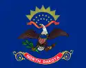
မြောက်ဒါကိုတာပြည်နယ်
| မြောက်ဒါကိုတာပြည်နယ် | |||||||||||
| |||||||||||
| ရုံးသုံးဘာသာစကားများ | English[1] | ||||||||||
| မြို့သား | North Dakotan | ||||||||||
| မြို့တော် | Bismarck | ||||||||||
| အကြီးဆုံးမြို့ | Fargo | ||||||||||
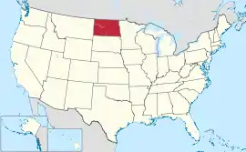
| ဧရိယာ | အမေရိကန်အဆင့် 19th | ||||||||||
| - စုစုပေါင်း | 70,700 စတုရန်းမိုင် (183,272 စတုရန်း ကီလိုမီတာ) | ||||||||||
| - အကျယ် | 210 miles (340 ကီလိုမီတာ) | ||||||||||
| - အရှည် | 340 miles (545 ကီလိုမီတာ) | ||||||||||
| - ရေရာခိုင်နှုန်း | 2.4 | ||||||||||
| - လတ္တီကျု | 45° 56′ N to 49° 00′ N | ||||||||||
| - လောင်ဂျီကျု | 96° 33′ W to 104° 03′ W | ||||||||||
| လူဦးရေ | အမေရိကန်အဆင့် 48th | ||||||||||
| - စုစုပေါင်း | 683,932 (2011 est) | ||||||||||
| - သိပ်သည်းမှု | 9.92/စတုရန်းမိုင် (3.83/စတုရန်းကီလိုမီတာ) အမေရိကန်အဆင့်47th | ||||||||||
| အမြင့် | |||||||||||
| - အမြင့်ဆုံးနေရာ | White Butte[2][3] 3,508 ပေ (1069 မီတာ) | ||||||||||
| - အလယ်အလတ် | 1,900 ပေ (580 မီတာ) | ||||||||||
| - အနိမ့်ဆုံးနေရာ | Red River of the North at Manitoba border[2][3] 751 ပေ (229 မီတာ) | ||||||||||
| ပြည်ထောင်စုသို့ ဝင်ရောက်ခြင်း |
November 2, 1889[a] (39th) | ||||||||||
| ပြည်နယ်အုပ်ချုပ်ရေးမှူး | Jack Dalrymple (R) | ||||||||||
| လက်ထောက် ပြည်နယ်အုပ်ချုပ်ရေးမှူး | Drew Wrigley (R) | ||||||||||
| ဥပဒေပြုလွှတ်တော် | Legislative Assembly | ||||||||||
| - အထက်လွှတ်တော် | Senate | ||||||||||
| - အောက်လွှတ်တော် | House of Representatives | ||||||||||
| ဆီးနိတ်အမတ်များ | Kent Conrad (D) John Hoeven (R) | ||||||||||
| အောက်လွှတ်တော် အမတ်များ | Rick Berg (R) (list) | ||||||||||
| စံတော်ချိန်ဇုန်များ | |||||||||||
| - most of state | Central: UTC-6/-5 | ||||||||||
| - southwest | Mountain: UTC-7/-6 | ||||||||||
| အတိုကောက်များ | ND US-ND | ||||||||||
| အင်တာနက်စာမျက်နှာ | http://www.nd.gov | ||||||||||
ကိုးကား
- North Dakota Century Code, CHAPTER 54-02-13
- Elevations and Distances in the United States။ United States Geological Survey (2001)။ October 24, 2011 တွင် ပြန်စစ်ပြီး။
- Elevation adjusted to North American Vertical Datum of 1988.
This article is issued from Wikipedia. The text is licensed under Creative Commons - Attribution - Sharealike. Additional terms may apply for the media files.