လက်တင်အမေရိက
လက်တင်အမေရိက (အင်္ဂလိပ်: Latin America) ဟူသည် ရိုမန်ဘာသာစကား (အဓိကအားဖြင့် စပိန်နှင့် ပေါ်တူဂီဘာသာ) ကိုပြောဆိုသည့် အမေရိကရှိ နိုင်ငံများကို ညွှန်းဆို ခေါ်ဝေါ်ခြင်းဖြစ်သည်။ အမေရိကန်ပြည်ထောင်စု တောင်ဖက်နယ်နမိတ်မှ တောင်အမေရိက တောင်ဖက် အစွန်းထိ (ကာရစ်ဘီယံဒေသ အပါအဝင်) ကျယ်ပြန့်ကာ အချုပ်အခြာအာဏာပိုင်နိုင်ငံပေါင်း ၂၀ ပါဝင်သည်။ ဧရိယာအားဖြင့် ၁၉,၁၉၇,၀၀၀ စတုရန်းကီလိုမီတာခန့် (၇,၄၁၂,၀၀၀ စတုရန်းမိုင်)[1] ကျယ်ဝန်းကာ ကမ္ဘာ့ကုန်းမြေစုစုပေါင်းဧရိယာ၏ ၁၃% ခန့်ရှိသည်။ လူဦးရေမှာ ၂၀၁၃ ခုနှစ် စာရင်းများအရ ၆၀၄ သန်းကျော်ဖြစ်သည်။ "လက်တင်အမေရိက" ဟူသည့် အသုံးအနှုန်းကို ၁၈၆၁ ခုနှစ်တွင် စတင်အသုံးပြုခဲ့သည်။ [5]
.svg.png.webp) | |
| ဧရိယာ | ၁၉,၁၉၇,၀၀၀ km2 (၇,၄၁၂,၀၀၀ sq mi)[1] |
|---|---|
| လူဦးရေ | ၆၂၆,၇၄၁,၀၀၀ (၂၀၁၅ ခန့်မှန်း)[2][မှတ်စု 2] |
| လူဦးရေ သိပ်သည်းမှု | ၃၁/km2 (၈၀/sq mi) |
| Demonym | Latin American |
| နိုင်ငံများ | ၂၀[မှတ်စု 3] |
| အမှီအခိုနယ်မြေများ | ၁၃ |
| ဘာသာစကားများ | အဓိကအားဖြင့် စပိန် နှင့် ပေါ်တူဂီ အခြား: Quechua, Mayan languages, Guaraní, ပြင်သစ်, Aymara, Nahuatl, အီတလီ၊ ဂျာမန်၊ အင်္ဂလိပ်၊ ဒတ်ချ်၊ ပိုလန်၊ ယူကရိန်း၊ Welsh, Yidish, တရုတ် |
| အချိန်ဇုန်များ | UTC-2 မှ UTC-8 |
| အကြီးဆုံးမြို့များ | (မြို့ကြီးများ)[3][4] ၁။ ၂။ ၃။ ၄။ ၅။ ၆။ ၇။ ၈။ ၉။ ၁၀။ |
နယ်မြေဒေသများ

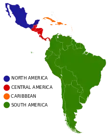
ပထဝီဝင်၊ နိုင်ငံရေး၊ ယဉ်ကျေးမှု စသည်တို့ကို အခြေခံ၍ လက်တင်အမေရိက ကို အမျိုးမျိုးခွဲခြားနိုင်သည်။ ပထဝီဝင်အားဖြင့် ပိုင်းခြားထားပုံမှာ မြောက်အမေရိက၊ ဗဟိုအမေရိက၊ ကာရစ်ဘီယံနှင့် တောင်အမေရိက ဟူ၍ဖြစ်သည်။[6] နိုင်ငံရေးပထဝီဝင်အရ ခွဲခြားထားသည့် နယ်မြေဒေသများမှာ တောင်ပိုင်းကတော့ပုံဒေသ၊ ဂီယားနားနယ်များနှင့် အန်းဒီးဒေသ တို့ဖြစ်သည်။ ဘာသာဗေဒအားဖြင့် ပိုင်းခြားထားသည့် ဒေသများမှာ ဟစ်စပန်းနစ်အမေရိက၊ ပေါ်တူဂီအမေရိကနှင့် ပြင်သစ်အမေရိက တို့ဖြစ်ကြသည်။
| အလံ | တံဆိပ် အမှတ်အသား | အမည် | ဧရိယာ (km²) |
လူဦးရေ |
လူဦးရေသိပ်သည်းဆ (per km²) |
မြို့တော် | နိုင်ငံအမည် (ရုံးသုံးဘာသာစကားဖြင့်) |
|---|---|---|---|---|---|---|---|
| အာဂျင်တီးနားနိုင်ငံ | ၂,၇၈၀,၄၀၀ | ၄၁,၆၆၀,၄၁၇ | ၁၄.၄ | ဗျူနိုအေးရိစ်မြို့ | Argentina | ||
| ဘိုလီးဗီးယားနိုင်ငံ | ၁,၀၉၈,၅၈၁ | ၁၀,၄၆၁,၀၅၃ | ၉ | ဆူးခရဲ့မြို့ | Bolivia | ||
| ဘရာဇီး | ၈,၅၁၅,၇၆၇ | ၂၀၁,၀၃၂,၇၁၄ | ၂၃.၆ | ဘရာဇီးလီးလားမြို့ | Brasil | ||
| ချီလီနိုင်ငံ | ၇၅၆,၀၉၆ | ၁၇,၅၅၆,၈၁၅ | ၂၃ | ဆန်တီယာဂိုမြို့ | Chile | ||
| ကိုလံဘီယာနိုင်ငံ | ၁,၁၄၁,၇၄၈ | ၄၇,၃၈၇,၁၀၉ | ၄၁.၅ | ဘိုဂိုတာမြို့ | Colombia | ||
| ကော့စတာရီကာနိုင်ငံ | ၅၁,၁၀၀ | ၄,၆၆၇,၀၉၆ | ၉၁.၃ | ဆန်ဂျို့စ်မြို့ | Costa Rica | ||
| ကျူးဘားနိုင်ငံ | ၁၀၉,၈၈၄ | ၁၁,၀၆၁,၈၈၆ | ၁၀၀.၆ | ဟာဗားနားမြို့ | Cuba | ||
| ဒိုမီနီကန်သမ္မတနိုင်ငံ | ၄၈,၄၄၂ | ၁၀,၂၁၉,၆၃၀ | ၂၁၀.၉ | ဆန်တိုဒိုမီဂိုမြို့ | República Dominicana | ||
| အီကွေဒေါနိုင်ငံ | ၂၈၃,၅၆၀ | ၁၅,၄၃၉,၄၂၉ | ၅၄.၄ | ကွီတိုမြို့ | Ecuador | ||
| အယ်ဆာဗေဒိုနိုင်ငံ | ၂၁,၀၄၀ | ၆,၁၀၈,၅၉၀ | ၂၉၀.၃ | ဆန်ဆာဗေဒိုမြို့ | El Salvador | ||
| ပြင်သစ်ဂီယားနား* | ၈၃,၅၃၄ | ၂၅၀,၁၀၉ | ၃ | ခေအန်းမြို့ | Guyane française | ||
| ဂွါဒီလု* | ၁,၆၂၈ | ၄၀၅,၇၃၉ | ၂၅၀ | ဘာ့စတဲမြို့ | Guadeloupe | ||
| ဂွါတီမာလာနိုင်ငံ | ၁၀၈,၈၈၉ | ၁၅,၄၃၈,၃၈၄ | ၁၂၉ | ဂွါတီမာလာစီးတီး | Guatemala | ||
| ဟေတီနိုင်ငံ | ၂၇,၇၅၀ | ၉,၉၉၆,၇၃၁ | ၃၅၀ | ပေါ့တ်အော်ရ်ပရင့်စ်မြို့ | Ayiti, Haïti | ||
| ဟွန်ဒူးရပ်စ်နိုင်ငံ | ၁၁၂,၄၉၂ | ၈,၅၅၅,၀၇၂ | ၇၆ | တေဂူဆီဂါလ်ပါမြို့ | Honduras | ||
| မာတီနစ်* | ၁,၁၂၈ | ၃၈၆,၄၈၆ | ၃၄၀ | ဖော့ဒီဖရန့်မြို့ | Martinique | ||
| မက္ကဆီကိုနိုင်ငံ | ၁,၉၇၂,၅၅၀ | ၁၁၈,၃၉၅,၀၅၄ | ၅၇ | မက္ကဆီကိုစီးတီး | Estados Unidos Mexicanos | ||
| နီကာရာဂွါနိုင်ငံ | ၁၃၀,၃၇၅ | ၅,၇၈၈,၅၃၁ | ၄၄.၃ | မနာဂွါမြို့ | Nicaragua | ||
| ပနားမားနိုင်ငံ | ၇၅,၅၁၇ | ၃,၆၆၁,၈၆၈ | ၅၄.၂ | ပနားမားစီးတီး | Panamá | ||
| ပါရာဂွေးနိုင်ငံ | ၄၀၆,၇၅၃ | ၆,၈၀၀,၂၈၄ | ၁၄.၂ | အဆွန်စီယုန်းမြို့ | Paraguay | ||
| ပီရူးနိုင်ငံ | ၁,၂၈၅,၂၁၆ | ၃၀,၄၇၅,၁၄၄ | ၂၃ | လီမာမြို့ | Perú | ||
| ပေါ်တိုရီကို* | ၉,၁၀၄ | ၃,၆၁၅,၀၈၆ | ၃၉၇ | ဆန်ဝှမ်းမြို့ | Puerto Rico | ||
| စိန့်ဘာသယ်လမီ* | ၅၃.၂ | ၃၆,၂၈၆ | ၆၈၂ | ဂစ်စတာဗီယားမြို့ | Saint-Barthélemy | ||
| [[File:|23x15px|border |alt=Collectivity of Saint Martin|link=Collectivity of Saint Martin]] | စိန့်မာတင်* | ၂၅ | ၉,၀၃၅ | ၃၆၁ | မာရီဂေါမြို့ | Saint-Martin | |
| ဥရုဂွေးနိုင်ငံ | ၁၇၆,၂၁၅ | ၃,၃၂၄,၄၆၀ | ၁၈.၈၇ | မွန်တီဗစ်ဒီအိုမြို့ | Uruguay | ||
| ဗင်နီဇွဲလားနိုင်ငံ | ၉၁၆,၄၄၅ | ၃၁,၆၄၈,၉၃၀ | ၃၁.၅၉ | ကရာကတ်စ်မြို့ | Venezuela | ||
| စုစုပေါင်း | ၂၀,၁၁၁,၄၅၇ | ၆၀၃,၄၄၁,၅၉၅ | ၃၀ | ||||
*: အချုပ်အခြာအာဏာပိုင်နိုင်ငံ မဟုတ်
မှတ်စုများ
- အဓိက လက်တင်အမေရိက ဘာသာစကားများဖြင့်
- Includes the population estimates for South American and Central American countries excluding Belize, Guyana, the United States, and Spanish and French speaking Caribbean countries and territories, as listed under "Sub-regions and countries"
- Not including Anglophone, Francophone or Dutch-speaking countries, such as Belize, Guyana, Suriname and Jamaica; see Contemporary Definitions section
ကိုးကား
- "World Development Indicators: Rural environment and land use"၊ World Development Indicators, The World Bank၊ ကမ္ဘာ့ဘဏ်၊ ၁၂ စက်တင်ဘာ ၂၀၁၃ တွင် ပြန်စစ်ပြီး
- Geography Department at Loughborough University, The World According to GaWC 2012, Table 4
- Phelan (1968), p. 296.
- María Alejandra Acosta García; Sheridan González, Ma. de Lourdes Romero, Luis Reza, Araceli Salinas (June 2011)။ "Three"။ in CONALITEG (ed.)။ Geografía, Quinto Grado (Geography, Fifth Grade) (Second Edition ed.)။ Mexico City: Secretaría de Educación Pública (Secretariat of Public Education)။ pp. 75–83။
|access-date=က|url=ကို လိုအပ်သည် (အကူအညီ)CS1 maint: multiple names: authors list (link) CS1 maint: extra text (link)
.svg.png.webp)

.svg.png.webp)
.svg.png.webp)

.svg.png.webp)
.svg.png.webp)
_political.svg.png.webp)
.svg.png.webp)
.svg.png.webp)
.svg.png.webp)
