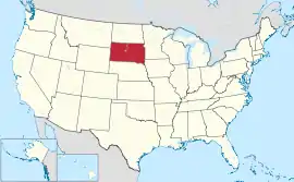
တောင်ဒါကိုတာပြည်နယ်
| တောင်ဒါကိုတာပြည်နယ် | |||||||||||
| |||||||||||
| ရုံးသုံးဘာသာစကားများ | English[1] | ||||||||||
| မြို့သား | South Dakotan | ||||||||||
| မြို့တော် | Pierre | ||||||||||
| အကြီးဆုံးမြို့ | Sioux Falls | ||||||||||
| အကြီးဆုံး မက်ထရိုဧရိယာ | Sioux Falls metropolitan area | ||||||||||
| ဧရိယာ | အမေရိကန်အဆင့် 17th | ||||||||||
| - စုစုပေါင်း | 77,116 စတုရန်းမိုင် (199,905 စတုရန်း ကီလိုမီတာ) | ||||||||||
| - အကျယ် | 210 miles (340 ကီလိုမီတာ) | ||||||||||
| - အရှည် | 380 miles (610 ကီလိုမီတာ) | ||||||||||
| - ရေရာခိုင်နှုန်း | 1.6 | ||||||||||
| - လတ္တီကျု | 42° 29′ N to 45° 56′ N | ||||||||||
| - လောင်ဂျီကျု | 96° 26′ W to 104° 03′ W | ||||||||||
| လူဦးရေ | အမေရိကန်အဆင့် 46th | ||||||||||
| - စုစုပေါင်း | 824,082 (2011 est) | ||||||||||
| - သိပ်သည်းမှု | 10.9/စတုရန်းမိုင် (4.19/စတုရန်းကီလိုမီတာ) အမေရိကန်အဆင့်46th | ||||||||||
| အမြင့် | |||||||||||
| - အမြင့်ဆုံးနေရာ | Harney Peak[2][3][4] 7,244 ပေ (2208 မီတာ) | ||||||||||
| - အလယ်အလတ် | 2,200 ပေ (670 မီတာ) | ||||||||||
| - အနိမ့်ဆုံးနေရာ | Big Stone Lake on Minnesota border[3][4] 968 ပေ (295 မီတာ) | ||||||||||
| ပြည်ထောင်စုသို့ ဝင်ရောက်ခြင်း |
November 2, 1889 (40th) | ||||||||||
| ပြည်နယ်အုပ်ချုပ်ရေးမှူး | Dennis Daugaard (R) | ||||||||||
| လက်ထောက် ပြည်နယ်အုပ်ချုပ်ရေးမှူး | Matt Michels (R) | ||||||||||
| ဥပဒေပြုလွှတ်တော် | South Dakota Legislature | ||||||||||
| - အထက်လွှတ်တော် | Senate | ||||||||||
| - အောက်လွှတ်တော် | House of Representatives | ||||||||||
| ဆီးနိတ်အမတ်များ | Tim Johnson (D) John Thune (R) | ||||||||||
| အောက်လွှတ်တော် အမတ်များ | Kristi Noem (R) (list) | ||||||||||
| စံတော်ချိန်ဇုန်များ | |||||||||||
| - eastern half | Central: UTC-6/-5 | ||||||||||
| - western half | Mountain: UTC-7/-6 | ||||||||||
| အတိုကောက်များ | SD US-SD | ||||||||||
| အင်တာနက်စာမျက်နှာ | http://www.sd.gov | ||||||||||


ကိုးကား
- South Dakota Codified Laws (1–27–20)။ South Dakota State Legislature။ April 27, 2010 တွင် ပြန်စစ်ပြီး။
- Harney။ NGS data sheet။ U.S. National Geodetic Survey။ October 24, 2011 တွင် ပြန်စစ်ပြီး။
- Elevations and Distances in the United States။ United States Geological Survey (2001)။ October 24, 2011 တွင် ပြန်စစ်ပြီး။
- Elevation adjusted to North American Vertical Datum of 1988.
This article is issued from Wikipedia. The text is licensed under Creative Commons - Attribution - Sharealike. Additional terms may apply for the media files.