နီဗားဒါးပြည်နယ်
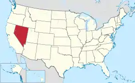
နီဗားဒါးပြည်နယ်သည် အမေရိကန် အနောက်ပိုင်းရှိ ပြည်နယ်တစ်ခုဖြစ်ပြီး အနောက်မြောက်တွင် အိုရီဂွန်ပြည်နယ်၊ အရှေ့မြောက်တွင် အိုင်ဒါဟိုပြည်နယ်၊ အနောက်ဘက်တွင် ကယ်လီဖိုးနီးယားပြည်နယ်၊ အရှေ့တောင်ဘက်တွင် အရီဇိုးနားပြည်နယ်နှင့် အရှေ့ဘက်တွင် ယူးတားပြည်နယ်တို့ဖြင့် နယ်နမိတ်ထိစပ်လျက်ရှိသည်။ မြို့တော်မှာ ကာဆန်းစီတီးဖြစ်ပြီး နီဗားဒါးပြည်နယ်ကို ငွေမြို့တော်ဟု တရားဝင်သိထားသည်။ အကြောင်းမှာ ယင်းပြည်နယ်မှ ငွေသတ္တုကို အများအပြားထုတ်လုပ်သောကြောင့်ဖြစ်သည်။ နီဗားဒါးပြည်နယ်သည် အများအားဖြင့် ကန္တာရများဖြင့် လွှမ်းခြုံထားပြီး ကုန်းမြေ၏ ၈၆ ရာခိုင်နှုန်းကို အမေရိကန်အစိုးရ၊ စစ်ဘက်ဆိုင်ရာနှင့် သာမန်ပြည်သူများက အသုံးပြုကြသည်။[5] ၁၉၄၀ ခုနှစ်တွင် လူဦးရေ ၁၁၀,၀၀၀ ရှိခဲ့ပြီး ၂၀ ရာစုတွင် ကမ္ဘာလှည့်ခရီးသည်များကို ဆွဲဆောင်သည့်နေရာဖြစ်လာခဲ့သည်။ နီဗားဒါးပြည်နယ်သည် ကမ္ဘာပေါ်တွင် စတုတ္ထမြောက် ရွှေအများဆုံးထုတ်လုပ်သည့်ပြည်နယ်တစ်ခုအဖြစ် ရပ်တည်လျက်ရှိသည်။[6]
| နီဗားဒါးပြည်နယ် | |||||||||||
| |||||||||||
| ရုံးသုံးဘာသာစကားများ | De jure: None De facto: English | ||||||||||
| မြို့သား | Nevadan | ||||||||||
| မြို့တော် | Carson City | ||||||||||
| အကြီးဆုံးမြို့ | Las Vegas | ||||||||||
| အကြီးဆုံး မက်ထရိုဧရိယာ | Las Vegas metropolitan area | ||||||||||
| ဧရိယာ | အမေရိကန်အဆင့် 7th | ||||||||||
| - စုစုပေါင်း | 110,622 စတုရန်းမိုင် (286,367 စတုရန်း ကီလိုမီတာ) | ||||||||||
| - အကျယ် | 322 miles (519 ကီလိုမီတာ) | ||||||||||
| - အရှည် | 492 miles (787 ကီလိုမီတာ) | ||||||||||
| - ရေရာခိုင်နှုန်း | |||||||||||
| - လတ္တီကျု | 35° N to 42° N | ||||||||||
| - လောင်ဂျီကျု | 114° 2′ W to 120° W | ||||||||||
| လူဦးရေ | အမေရိကန်အဆင့် 35th | ||||||||||
| - စုစုပေါင်း | 2,723,322 (2011 est) | ||||||||||
| - သိပ်သည်းမှု | 24.8/စတုရန်းမိုင် (9.57/စတုရန်းကီလိုမီတာ) အမေရိကန်အဆင့်42nd | ||||||||||
| - အလယ်အလတ် ဝင်ငွေ | $56,361 (15th) | ||||||||||
| အမြင့် | |||||||||||
| - အမြင့်ဆုံးနေရာ | Boundary Peak[1][2][3][4] 13,147 ပေ (4007.1 မီတာ) | ||||||||||
| - အလယ်အလတ် | 5,500 ပေ (1680 မီတာ) | ||||||||||
| - အနိမ့်ဆုံးနေရာ | Colorado River at California border[2][3] 481 ပေ (147 မီတာ) | ||||||||||
| ပြည်ထောင်စုသို့ ဝင်ရောက်ခြင်း |
October 31, 1864 (36th) | ||||||||||
| ပြည်နယ်အုပ်ချုပ်ရေးမှူး | Brian Sandoval (R) | ||||||||||
| လက်ထောက် ပြည်နယ်အုပ်ချုပ်ရေးမှူး | Brian Krolicki (R) | ||||||||||
| ဥပဒေပြုလွှတ်တော် | Nevada Legislature | ||||||||||
| - အထက်လွှတ်တော် | Senate | ||||||||||
| - အောက်လွှတ်တော် | Assembly | ||||||||||
| ဆီးနိတ်အမတ်များ | Harry Reid (D) Dean Heller (R) | ||||||||||
| အောက်လွှတ်တော် အမတ်များ | 1: Shelley Berkley (D) 2: Mark Amodei (R) 3: Joe Heck (R) (list) | ||||||||||
| စံတော်ချိန်ဇုန်များ | |||||||||||
| - most of state | Pacific: UTC-8/-7 | ||||||||||
| - West Wendover | Mountain: UTC-7/-6 | ||||||||||
| အတိုကောက်များ | NV Nev. US-NV | ||||||||||
| အင်တာနက်စာမျက်နှာ | http://www.nv.gov | ||||||||||
ကိုးကား
- Boundary။ NGS data sheet။ U.S. National Geodetic Survey။ October 20, 2011 တွင် ပြန်စစ်ပြီး။
- Elevations and Distances in the United States။ United States Geological Survey (2001)။ October 24, 2011 တွင် ပြန်စစ်ပြီး။
- Elevation adjusted to North American Vertical Datum of 1988.
- The distinction of highest point in Nevada goes to the summit of Boundary Peak, so named because it is very near the Nevada-California border, at the northern terminus of the White Mountains. However, Boundary Peak can be considered a subsidiary summit of Montgomery Peak, whose summit is in California, since the topographic prominence of Boundary Peak is only ၂၅၃ ပေ (၇၇ မီတာ), which falls under the often used ၃၀၀-ပေ (၉၁-မီတာ) cutoff for an independent peak. Also, Boundary Peak is less than ၁ မိုင် (၁.၆ ကီလိုမီတာ) away from its higher neighbor. Hence Boundary Peak can be described as not being wholly within Nevada. By contrast, the prominence of Wheeler Peak, ၁၃,၀၆၃ ပေ (၃,၉၈၂ မီတာ), is quite large and in fact it is the twelfth largest in the contiguous United States. Wheeler Peak is the highest point in a radius of more than ၂၀၀ စတုရန်းမိုင် (၅၂၀ စတုရန်း ကီလိုမီတာ) and is entirely within the state of Nevada.
- Federal Land Acres in Nevada။ U.S. Dept. of the Interior, Bureau of Land Management။ September 30, 2006 တွင် မူရင်းအား မော်ကွန်းတင်ပြီး။ May 7, 2009 တွင် ပြန်စစ်ပြီး။
- "Frequently Asked Questions", Nevada Mining Association, accessed January 7, 2011.