ဂျေရုဆလင်မြို့
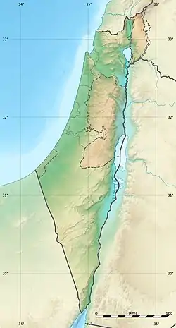
ဂျေရုဆလင်မြို့ (ဟီဘရူး יְרוּשָׁלַיִם ; အာရပ် القُدس ) သည် အစ္စရေးနိုင်ငံ၏ သာသနာအရ အထွဋ်အမြတ်ထားသောမြို့တော်ဖြစ်သည့်အပြင် ဧရိယာ အကျယ်အဝန်းအားဖြင့် လည်းကောင်း လူဦးရေအားဖြင့်လည်းကောင်း အကြီးဆုံးမြို့လည်း ဖြစ်သည်။[8][9] လက်ရှိ ဂျေရုဆလင်မြို့ရှိ လူဦးရေမှာ ၇၆၃,၈၀၀ ဖြစ်ပြီး အရှေ့ဂျေရုဆလင် ပါဝင်လျှင် မြို့ဧရိယာမှာ ၁၂၅.၁ km2 ကျယ်ဝန်းသည်။ [10] ဂျေရုဆလင်သည် မြေထဲပင်လယ်နှင့် ပင်လယ်သေအကြား တောင်တန်းပေါ်တွင် တည်ရှိသည်။ ခေတ်သစ် ဂျေရုဆလင်မြို့သည် ယခုအခါတွင် ဂျေရုဆလင်မြို့ဟောင်းထက် များစွာ ဖွံ့ဖြိုးလာပြီဖြစ်သည်။ ဂျက်ဖားသင်္ဘောဆိပ်မြို့၏ အနောက်တောင်ဘက် ၃၅ မိုင်ကွာ ၌ရှိသော တောင်ကုန်းမြင့်တစ်ခုပေါ်တွင် တည်ရှိ၏။ ဂျူး၊ ခရစ်ယာန် နှင့် အစ္စလာမ် ဘာသာတို့ အထွတ်အမြတ်ထားသည့် သာသနာဆိုင်ရာ မြို့တော်ကြီး ဖြစ်သည်။
| ဂျေရုဆလင်မြို့ Jerusalem
| |||
|---|---|---|---|
| မြို့ | |||
 | |||
| |||
| နာမည်ပြောင်(များ): Ir ha-Kodesh (The Holy City), Bayt al-Maqdis (House of the Holiness) | |||
 ဂျေရုဆလင်မြို့ Jerusalem  ဂျေရုဆလင်မြို့ Jerusalem ဖိုင်:Earthmap1000x500compac.jpg ဂျေရုဆလင်မြို့ Jerusalem | |||
| ကိုဩဒိနိတ်: 31°47′N 35°13′E | |||
| အုပ်ချုပ်သူ | အစ္စရေးနိုင်ငံ | ||
| ပိုင်ဆိုင်ကြောင်း ဆိုသူ | အစ္စရေးနိုင်ငံ နှင့် ပါလက်စတိုင်း [note 1] | ||
| ခရိုင် | ဂျေရုဆလင်ခရိုင် | ||
| Palestinian governorate | ဂျေရုဆလင် | ||
| Gihon Spring settlement | ဘီစီ ၃၀၀၀–၂၈၀၀ | ||
| City of David | ဘီစီ ၁၀၀၀ ခန့် | ||
| လက်ရှိ မြို့ရိုးဟောင်း တည်ဆောက် | ၁၅၄၁ | ||
| ဂျေရုဆလင် အရှေ့-အနောက် ကွဲခြင်း | ၁၉၄၈ | ||
| ပြန်လည်ပေါင်းစည်း | ၁၉၆၇ | ||
| အစိုးရ | |||
| • အမျိုးအစား | Mayor–council | ||
| • အစိုးရအဖွဲ့ | Jerusalem Municipality | ||
| • အစ္စရေးမြို့တော်ဝန် | Moshe Lion (Likud) | ||
| • ပါလက်စတိုင်းမြို့တော်ဝန် (အရှေ့) | Zaki al-Ghul (titular) | ||
| ဧရိယာ | |||
| • မြို့ | ၁၂၅၁၅၆ dunams (၁၂၅.၁၅၆ စတုရန်းကီလိုမီတာ or ၄၈.၃၂၃ စတုရန်းမိုင်) | ||
| • မြို့ပြကြီး | ၆၅၂၀၀၀ dunams (၆၅၂ စတုရန်းကီလိုမီတာ or ၂၅၂ စတုရန်းမိုင်) | ||
| ပင်လယ်ရေ မျက်နှာပြင်အမြင့် | ၇၅၄ မီတာ (၂၄၇၄ ပေ) | ||
| လူဦးရေ (တမ်းပလိတ်:Israel populations)တမ်းပလိတ်:Israel populations | |||
| • မြို့ | တမ်းပလိတ်:Israel populations | ||
| • မြို့ပြကြီး[5] | ၁,၂၅၃,၉၀၀ | ||
| Demographics (၂၀၁၆)[6] | |||
| • Jewish | ၆၀.၈% | ||
| • Arab | ၃၇.၇% | ||
| • အခြား | ၁.၅% | ||
| အချိန်ဇုန် | IST, PST (UTC+02:00) | ||
| • နွေရာသီ (DST) | IDT, PDT (UTC+03:00) | ||
| စာပို့သင်္ကေတ | 9XXXXXX | ||
| တယ်လီဖုန်းကုဒ် | +972-2 | ||
| HDI (၂၀၁၇) | ၀.၇၀၄[7] – မြင့် | ||
| ဝက်ဘ်ဆိုဒ် | jerusalem.muni.il | ||
မမှန်ကန်သော ရွေးချယ်ထားမှု | |||
| တရားဝင်အမည် | ဂျေရုဆလင်မြို့တော်ဟောင်းနှင့် မြို့ရိုးများ | ||
| အမျိုးအစား | ယဉ်ကျေးမှု | ||
| ရွေးချယ်သည့်စံနှုန်း | ii, iii, vi | ||
| ရွေးချယ်ခြင်း | ၁၉၈၁ | ||
| ရည်ညွှန်းနံပါတ် | 148 | ||
| ဒေသ | ဂျေရုဆလင်ခရိုင် | ||
| ပျောက်ပျက်ရန် စိုးရိမ်ရမှု | ၁၉၈၂–လက်ရှိ | ||


.jpg.webp)

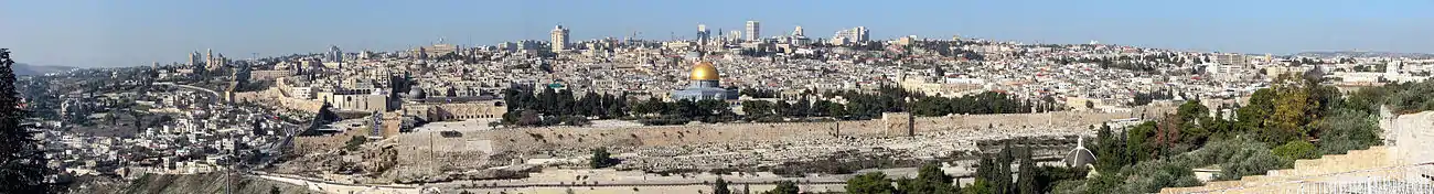
'ဂျေရုစလင်'၏ အဓိပ္ပာယ်မှာ ငြိမ်းချမ်းရေးမြို့တော်ဖြစ်၏။ သို့သော်လည်း ဤမြို့၌ မကြာခဏ စစ်ပွဲများ ဖြစ်ပွားသောကြောင့် မကြာခဏ ပြန်လည် ပြင်ဆင်တည်ဆောက်ခဲ့ရသဖြင့် ထိုမြို့သည် ကမ္ဘာပေါ်ရှိမြို့အပေါင်းတို့တွင် ငြိမ်းချမ်းမှု အနည်းဆုံးမြို့ ဖြစ်ပေသည်။ ယခုမြို့၏ မြေအောက်ပေ ၃၀ ခန့်တွင် ရှေးခေတ်က ရောမလူမျိုးတို့ ဖောက်လုပ်ထားခဲ့သည့် လမ်းမကြီးကို တွေ့နိုင်လေသည်။ အမှန်စင်စစ် ဂျေရုဆလင်မြို့သည် မြို့ ၃ မျက်နှာကို နက်ရှိုင်းသောချောက်ကြီး ၃ ခု ဝန်းရံနေ သောကြောင့် သဘာဝခံတပ်မြို့တစ်မြို့ ဖြစ်၏။
အရှေ့နှင့် အရှေ့မြောက်ဖက်တွင် ကစ်ဒရွန်ချောက်ကြီးသည် မြို့တော်ကို သံလွင်ပင်ကြီးများပေါက်ရောက်ရာ သံလွင်တောင်မှ ခြားထား၏။ အနောက်ဖက်တွင် တောင်ဖက်သို့ တန်းသွားသော ဟင်နွန်(ဝါ) ဂီဟင်းနာချိုင့်ဝှမ်းကြီး ရှိသည်။ ယင်းမှာ ရှေးက ဖီနီရှန်လူမျိုးတို့ လူကိုသတ်ဖြတ် ယဇ်ပူဇော်ရာနေရာ ဖြစ်သည်။
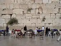
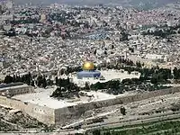
ဂျေရုစလင်မြို့ရိုးမှာ ကြိမ်ဖန်များစွာ ဖျက်ဆီးခြင်း ခံခဲ့ရသည့်ပြင် အဖန်ဖန် ပြန်လည်ပြင်ဆင် တည်ဆောက်ခဲ့ရသော မြို့ရိုးဖြစ်၍ ယခု မြို့တံခါး ၈ ပေါက်မှာ ၁၆ ရာစုနှစ်က စူလတန်ဘုရင် ဆူလေမန် တည်ဆောက်ထားခဲ့သော တံခါးများ ဖြစ်၏။ မြို့၏ တောင်ဖက်တွင် ဂျူးတို့ အထွတ်အမြတ်ထားရာ ဘုရားဝတ်ပြု တန်ဆောင်းကြီးတစ်ခု၏ နံရံဟောင်းတစ်ခု ရှိသည်။ ယင်းတန်ဆောင်းမှာ ရဟူဒီဘုရင်ကြီး ဆော်လမွန် တည်ဆောက်ခဲ့သော အဆောက်အအုံကြီးတစ်ခုဟု ယုံကြည်ကြလေသည်။ သောကြာနေ့တိုင်း ရဟူဒီဘုရားဖူးတို့သည် ဤနံရံဟောင်းကြီးကို နဖူးနှင့်ကပ်လျက် ငိုကြွေး မြည်တမ်းကာ ရှေးခေတ်ဟောင်းက ရဟူဒီတို့ ခမ်းနားကြီး ကျယ်ခဲ့ပုံကို အောက်မေ့တမ်းတလေ့ရှိသဖြင့် ငိုကြွေးရာတံတိုင်းဟု အမည်တွင် လျက်ရှိသည်။ ယင်းသည့် ရဟူဒီ တန်ဆောင်းကြီးနေရာတွင် မူစလင်တို့၏ အိုမာဗလီဝတ် ကျောင်းကြီးကို ကျောက်သားဖြင့် လှပစွာ ဆောက်လုပ်ထားလေသည်။ ဂျေရုဆလင်မြို့တွင် ခရစ်ယာန်ဘုရားဖူးတို့ အထူး သွားရောက် ဖူးမျှော်တတ်သောနေရာကား ဟိုးလီးဆီးပါးလခါး ဘုရားရှိခိုးကျောင်းဖြစ်၏။ ထိုကျောင်းတော်ရာမှာ ခရစ်တော်၏သင်္ချိုင်းရာ ဖြစ်သည်ဟု ယုံကြည်ကြ၏။ အမှန်စင်စစ် ခရစ်တော်အား ကားစင်တင်သတ်သော လက်ဝါးကပ် တိုင်တည်ရာ ခရစ်တော်အား မြှုပ်နှံရာနေရာတို့ကို မည်သူမျှ အတိအကျ မပြနိုင်ကြချေ။ သို့ရာတွင် မြင့်မြတ်သောနေရာကို ရည်မှန်း၍သာလျှင် ဖူးမြော်နေကြလေသည်။
မြို့တော်ဟောင်း၏လမ်းများမှာ ကျဉ်းမြောင်းကောက်ကွေ့၏။ မြို့ရိုးပြင်ဘက် ဆင်ခြေဖုံးများတွင် ကျယ်ပြန့်၍ ဘေးတဖက်တချက်တွင် သစ်ပင်စိုက်ထားသော လမ်းမကြီးများ၊ ဥယျာဉ်များနှင့် အဆောက်အအုံများ ရှိ၏။ မြို့တော်၏အကြီးဆုံး ရပ်ကွက်သစ်မှာ ဂျက်ဖားတံခါးမကြီး၏ အနောက်ဘက်တွင် ရှိလေသည်။
ဘီစီ ၁၄၀၀ ပြည့်နှစ်ခန့်တွင် ဤမြို့တော်ကို အီဂျစ် လက်အောက်ခံ ဘုရင်တစ်ပါးက အုပ်ချုပ်ခဲ့၏။ ထို့နောက် ဘီစီ ၁၀၀၀ ခန့်လောက်တွင် ဒေးဗစ်ဘုရင် သည် ဂျေရုဆလင်ကို ယဟူဒီနိုင်ငံသစ်၏မြို့တော် ပြုလုပ်ခဲ့လေသည်။ ဘီစီ ၅၈၆ ခုနှစ်တွင် ဗက်ဗီလုံးဘုရင် နက်ဗူခတ်နက်ဇာသည် ဂျေရုဆလင်မြို့ကို သိမ်းပိုက်၍ မြို့သူမြို့သား အမြောက်အမြားကို ဖမ်းဆီး ခေါ်ဆောင်သွားလေသည်။ ပါရှားဘုရင် ဆိုင်းရပ်လက်ထက်တွင် မြို့သစ်ပြန်တည်၍ ဘီစီ ၄၄၅ ခုနှစ်လောက်တွင် မြို့ရိုး များကို အသစ်ပြန်လည်၍ ဆောက်လုပ်ခဲ့လေသည်။ ထိုမှတစ်ဖန် ဂျေရုဆလင်မြို့သည် ဂရိဘုရင် အယ်လက်ဇန္နား-သည်-ဂရိတ်၏ လက်အောက်သို့ ကျရောက်ခဲ့ပြန်သည်။ နောင်အခါတွင် ဆီးရီးယန်းနှင့် အီဂျစ်ဘုရင်တို့ သူတပြန်ငါတပြန် တိုက်ခိုက်သိမ်းပိုက်ခြင်း ခံခဲ့ရပြန်၏။ ဘီစီ ၆၃ ခုနှစ်တွင် ရောမစစ်ဗိုလ်ကြီး ပွန်ပီက သိမ်းပိုက်ခဲ့၏။ ရောမတို့ လက်အောက်တွင် ယဟူဒီလူမျိုးများက ထကြွပုန်ကန်သဖြင့် မြို့ကို ၂ ကြိမ်မျှ ဖျက်ဆီးပစ်လိုက်ခြင်း ခံရ၏။ အေဒီ ၆၃၇ ခုနှစ်တွင် မူစလင်တို့က သိမ်းပိုက်လိုက်၏။ ဂျေရုစလင်မြို့သည် တူရကီနှင့် အီဂျစ်လူမျိုးတို့လက်ထဲမှ ၁၀၉၉ ခုနှစ်တွင် ကရူးဆိတ် စစ်ဆင်သူ ဥရောပဘုရင်များ၏လက်သို့ ကျရောက်ခဲ့ရ၏။ ၁၁၈၇ ခုနှစ်တွင် အာရပ်မူစလင်ခေါင်းဆောင် ဆဲလဒင်းက ပြန်လည် သိမ်းပိုက်ခဲ့၍ ၁၅၁၇ ခုနှစ်တွင် တူရကီတို့ လက်ထဲသို့ ရောက်သွား၏။ ၁၁၈၇ နှစ်မှ ၁၁၉၇ ခု ဗြိတိသျှ စစ်တပ်များက သိမ်းပိုက်သည်အထိ မူစလင်တို့ လက်ထဲ၌ ရှိခဲ့ပေသည်။
(ဗြိတိသျှတို့သိမ်းပိုက်ပြီးနောက်ဂျေရုစလင်၏သမိုင်းစဉ်အတွက် အစ္စရေးနိုင်ငံ။) ဂျေရုစလင်မြို့နှင့် ခရိုင်မှာ ယခုအခါ အစ္စရေးနိုင်ငံ အစိုးရနှင့် ဂျော်ဒန်နိုင်ငံ အစိုးရတို့ ခွဲဝေအုပ်ချုပ်လျက်ရှိ၏။ မြို့ဟောင်းကို ဂျော်ဒန်ကပိုင်၍ မြို့သစ်ကို အစ္စရေးကပိုင်သည်။ မြို့ဟောင်းတွင် အထွတ်အမြတ်နေရာ ၃၄ ခု ရှိသည်။ မြို့သစ်၌မူ အထွတ်အမြတ်ထားရာနေရာ ၂ ခုသာ ရှိသည်။ ဂျေရုဆလင်မြို့သည် ၁၉၅၀ ပြည့်နှစ် ဇန်နဝါရီလ ၂၃ ရက်နေ့ မှစ၍ အဇ္ဇရီယယ်နိုင်ငံ၏ မြို့တော်ဖြစ်ခဲ့လေသည်။ လူဦးရေမှာ ၁၉၅၃ ခုနှစ်တွင် ကောက်ယူခဲ့သော သန်းခေါင်စာရင်းအရ ၁၄၃၅၀၀ ဖြစ်လေသည်။ [11]
ပြတိုက်
 ယေရုရှလင်မြို့ အလင်း လက်ရန်းတန်း
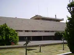
 အစ္စရေးတရားရုံးချုပ်
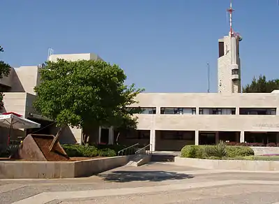
 အစ္စရေးနိုင်ငံခြားရေးဝန်ကြီးဌာန
 အစ္စရေးဝန်ကြီးချုပ်နေအိမ်
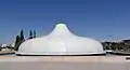
 အစ္စရေးအမျိုးသားသင်္ချိုင်း
 ဣသရေလအမျိုး၏ အမျိုးသားရုက္ခဗေဒဥယျာဉ်
 ဂျေရုဆလင်မြို့အပြည်ပြည်ဆိုင်ရာကွန်ဗင်းရှင်းစင်တာ
 အစ္စရေး သိပ္ပံနှင့်လူမှုအကယ်ဒမီ
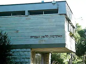
 ဘဇလဲ အနုပညာနှင့်ဒီဇိုင်းအကယ်ဒမီ
 အစ္စရေးရုပ်မြင်သံကြား
ကြည့်ရန်
မှတ်စုများ
- The State of Palestine (according to the Basic Law of Palestine, Title One: Article 3) regards Jerusalem as its capital.[1] But the documents of the PLO's Negotiations Affairs Department (NAD) often refer to East Jerusalem (rather than the whole of Jerusalem) as a future capital, and sometimes as the current capital. One of its 2010 documents, described as "for discussion purposes only", says that Palestine has a '"vision"' for a future in which "East Jerusalem ... shall be the capital of Palestine, and West Jerusalem shall be the capital of Israel",[2][3] and one of its 2013 documents refers to "Palestine's capital, East Jerusalem", and states that "Occupied East Jerusalem is the natural socio-economic and political center for the future Palestinian state", while also stating that "Jerusalem has always been and remains the political, administrative and spiritual heart of Palestine" and that "The Palestinian acceptance of the 1967 border, which includes East Jerusalem, is a painful compromise".[4]
ကိုးကား
- 2003 Amended Basic Law. Basic Law of Palestine. Retrieved: 9 December 2012.
- Jerusalem Non-Paper။ PLO-NAD (June 2010)။
- Statements and Speeches။ nad-plo.org။ “"This paper is for discussion purposes only. Nothing is agreed until everything is agreed.
Palestinian vision for Jerusalem
...
Pursuant to our vision, East Jerusalem, as defined by its pre-1967 occupation municipal borders, shall be the capital of Palestine, and West Jerusalem shall be the capital of Israel, with each state enjoying full sovereignty over its respective part of the city."” - East Jerusalem today – Palestine's Capital: The 1967 border in Jerusalem and Israel's illegal policies on the ground။ PLO-Negotiations Affairs Department (NAD) (August 2013)။ “" ... Palestine's capital, East Jerusalem ... The Palestinian acceptance of the 1967 border, which includes East Jerusalem, is a painful compromise: ... Jerusalem has always been and remains the political, administrative and spiritual heart of Palestine. Occupied East Jerusalem is the natural socio-economic and political center for the future Palestinian state."”
- Localities, Population and Density per Sq. Km., by Metropolitan Area and Selected Localities။ Israel Central Bureau of Statistics (6 September 2017)။
- You must specify title = and url = when using {{cite web}}.။ jerusalem.muni.il (2017)။
- Area Database (in en)။ Global Data Lab။
- Largest city: "...modern Jerusalem, Israel's largest city..." (Erlanger, Steven. Jerusalem, Now, The New York Times, April 16, 2006.)
- Press Release: Jerusalem Day (PDF)။ Central Bureau of Statistics (2006-05-24)။ 2007-03-10 တွင် ပြန်စစ်ပြီး။
- Local Authorities in Israel 2007, Publication #1295 - Municipality Profiles - Jerusalem (PDF) (in Hebrew)။ Israel Central Bureau of Statistics။ 2007-12-31 တွင် ပြန်စစ်ပြီး။
- မြန်မာ့စွယ်စုံကျမ်း၊ အတွဲ(၃)
ပြင်ပလင့်ခ်များ
| Wikimedia Commons တွင် Jerusalem နှင့် ပတ်သက်သော မီဒီယာ ရှိသည်။ |
- ဂျေရုဆလင်မြို့ ဝဘ်ဆိုဒ်
- ဂျေရုဆလင် mp3 Archived 1 August 2015 at the Wayback Machine.
အစိုးရဌာန
ယဉ်ကျေးမှု
- အစ္စရေးပြတိုက်
- Yad Vashem, Israeli memorial to victims of The Holocaust
- ဂျေရုဆလင် ပွဲတော် လမ်းညွှန်
ပညာရေး
- ဟီဘရူး တက္ကသိုလ်
- အယ်ကွဒ် တက္ကသိုလ် ("ဂျေရုဆလင်ရှိ တစ်ခုတည်းသော အာရပ် တက္ကသိုလ်")
မြေပုံ
- ခေတ်သစ် ဂျေရုဆလင်မြို့၏ မြေပုံ (မြူနီစပယ်အစိုးရ)
- ဂျေရုဆလင်၏ ရှေးမြေပုံ Archived 11 April 2006 at the Wayback Machine. (ယဟူဒီအမျိုးသား စာကြည့်တိုက် ဟီဘရူးတက္ကသိုလ်)
- ၁၉၄၇ ခုနှစ်လွန်ကာလ မြေပုံ Archived 16 June 2008 at the Wayback Machine. (PASSIA)